2D Maps

Please note:
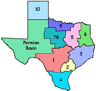
These maps include only lines for which
we have been provided digital locations.
Additional 2D lines may be available for
your area of interest.
Please contact your
American Geophysical representative.
Disclaimer
By accessing this website, you acknowledge and agree to the following:
All data shown is pending final owner approval and line/survey locations are provided "as is" and are approximate.
American Geophysical does not warrant the accuracy of the materials contained on this website.
Permission is granted to temporarily view the materials provided with the understanding that all information displayed shall not be copied/transferred.
|
|
|
|
|
|
Please note: These maps include only lines for which we have been provided digital locations. Additional 2D lines may be available for your area of interest. Please contact your American Geophysical representative. |
Disclaimer
By accessing this website, you acknowledge and agree to the following:
All data shown is pending final owner approval and line/survey locations are provided "as is" and are approximate.
American Geophysical does not warrant the accuracy of the materials contained on this website.
Permission is granted to temporarily view the materials provided with the understanding that all information displayed shall not be copied/transferred.